documenting flood risk
Lived Experiences and Visioning in Puerto Nuevo, San Juan PR
Qualitative Research | 2021
In summer 2021, I was part of an interdisciplinary fellowship looking to increase community engagement in flood risk management in the Río Piedras Watershed in San Juan, Puerto Rico. Our research was guided by a local knowledge-broker organization, the Alianza por la Cuenca del Río Piedras (the Alliance for the Río Piedras Watershed). The Alianza is working to connect communities and amplify local voices to inform watershed-scale flood management.
Recent hurricanes have prompted flood risk mitigation efforts in San Juan, especially the Río Piedras River. The Río Piedras is the only river in SJ and has been heavily altered throughout the city’s development. A project by the US Army Corps of Engineers (USACE) was approved in 1978 to channelize and harden many areas in the river, but was stopped in 1995 due to budget cuts. Hurricane Maria in 2016 renewed federal urgency in addressing flood risk in San Juan and $1.5 billion was reallocated to this project despite the research supporting it being decades old. While there is a consensus that flood risk is an urgent issue which must be addressed, many groups feel that the large-scale transformation of the Río Piedras must be developed using a social-ecological-technological (SETS) approach, and the current USACE project must include nature-based infrastructure and greater community engagement in developing the plan.
Our research team worked with the Alianza to support community engagement in flood decision-making in SJ’s Puerto Nuevo neighborhood. Located downstream, flood risk in Puerto Nuevo (PN) is highly influenced by decisions made throughout the watershed. Despite this, the PN community has been historically underrepresented in decision-making. Since 1960, development in PN has reduced green cover by 60%, while rates of poverty, rental units, and vacant housing units have increased. Increase in impermeable surface cover and aging infrastructure increase flood risk and flood diversion into the Río Piedras River. As it stands now, USACE’s channelization plan will not address drivers of flood risk in this area and will displace residents in 18 homes in this area.
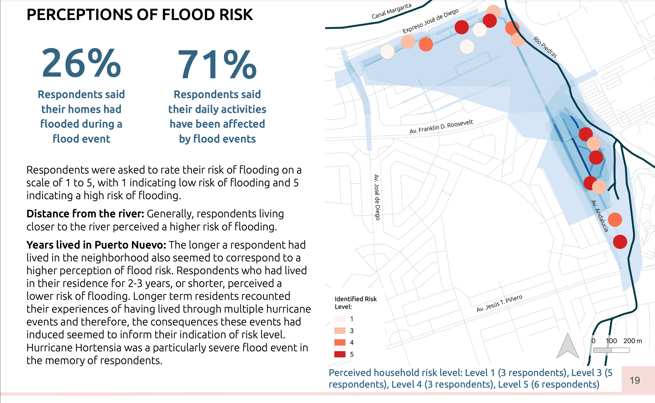
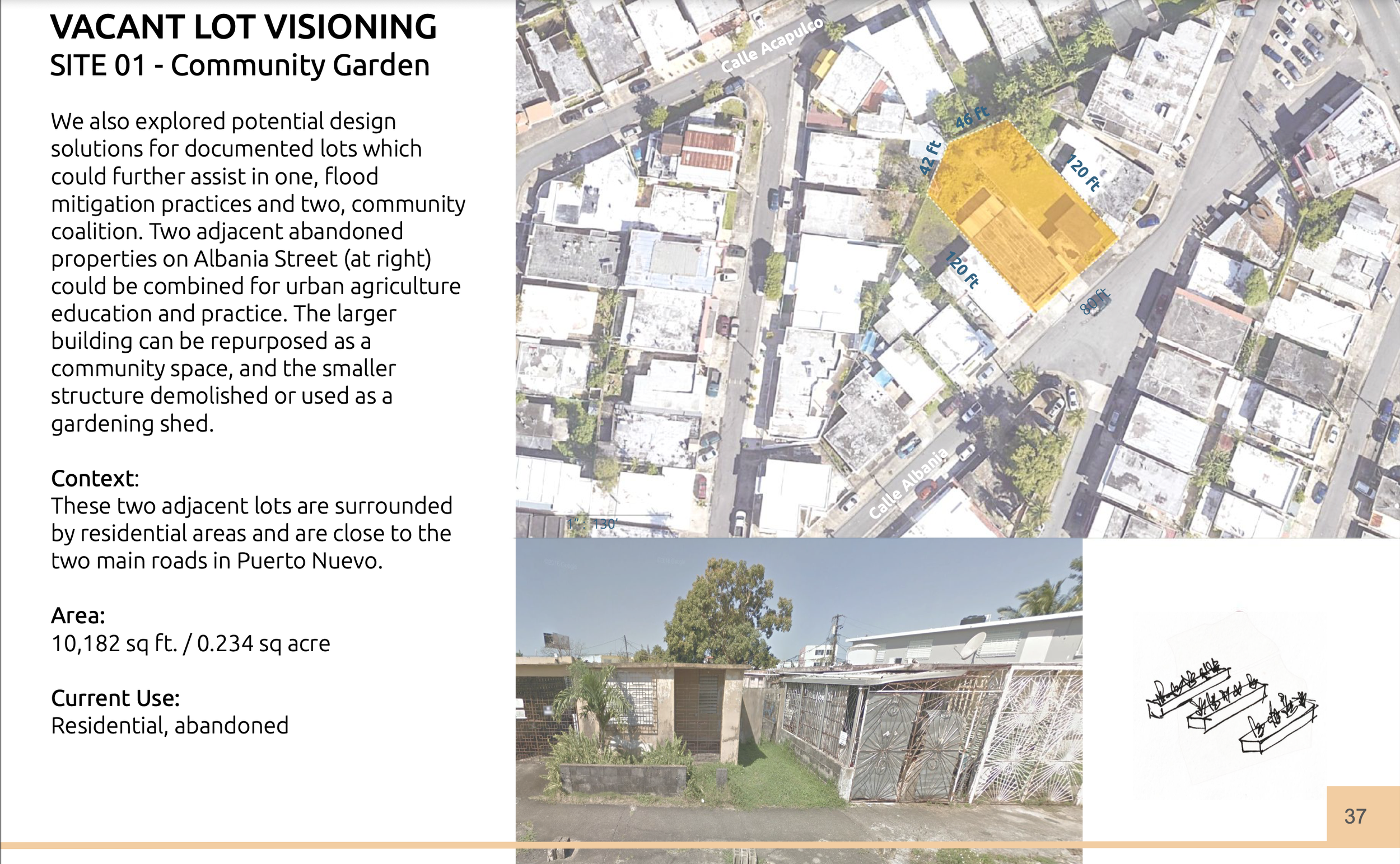
Our team conducted interviews with 21 residents in the PN neighborhood (in the FEMA Special Flood Hazard Area) to understand perceptions of the Río Piedras, flood experiences, visions for the river and flood control, alternative uses for vacant and abandoned properties, and awareness of the USACE plan. We conducted participatory flood mapping with residents to add a geospatial component to our interview data. We also conducted a walking census of abandoned properties within Puerto Nuevo to understand the magnitude of vacant and abandoned housing. The most exciting facet of our experience was the chance to use our position and resources to support local community action, under the guidance of the Alianza and others. Through our interviews with Puerto Nuevo Residents, we were able to support a dialogue about the Río’s future, as well as its proposed channelization. We invited residents to a town hall meeting led by the Alianza to talk about it. Following the community discussion, residents formed their own community group “Amigos del Puerto Nuevo,” to continue discussing and connect with other community organizations throughout the watershed. Overall, our experience was very meaningful in being able to conduct place-based transdisciplinary knowledge-action research.
Collaborators: Alianza por la Cuenca del Río Piedras, Universidad de Puerto Rico, Amigos del Río Piedras, NATURA Net
VIEW FULL VISUAL ESSAY HERE